Saturday, May 24, 2014

California's LOST COAST TRAIL May 2014

I went on a 4 day backpacking trip in northern California on the LOST COAST TRAIL in MAY 2014. This was a spectacular backpacking trip and I will remember it always.

The slide show I created has The Little River Band's "Cool Change" accompanying it.

For higher quality versions of the pictures used in this video, please see my LOST COAST album.

Relax and enjoy the serenity that this video invokes :-)


Saturday, March 15, 2014

Lookout Mountain, Umpqua National Forest, Oregon

 
(Click on any picture for larger view and slide show)
 
NOTE: See the end of this article for directions to the shortest hike I know of in Douglas County with tremendous views of mountains in every direction!!
 
 
There are a few things that you learn as a hiker:
First: have your hike well-planned.
Second: Have a back-up hike planned, just in case.
Third: If the first two plans fail, then just wing it.
 
Ok, so you already know where this one’s heading …
 
After hopping out of bed with more enthusiasm than I do for work (imagine that) I was up and out the door greeting the rising sun on my way to said planned hike on this fine mid-March morning!
 
My planned hike!

A sign of things to come...almost stopped in my tracks...
 
The actual sign which almost stopped me...
 I soon found myself on an ill-maintained forest service road, which involved negotiating my truck under a fallen tree, stopping to move a few pint-sized boulders out of the way, and then wondering what I was getting myself in to when I read the sign at the trailhead which read “Caution: This trail is not maintained and may be difficult to follow”.
 
Ok, this sounds like a challenge.
 
What the heck, let’s get this hike going…
 
 
I was stopped by this quaint creek...

Minutes later, on my short walk back to the truck after taking a few pictures of the quaint little creek which I was unable to traverse, I pondered my backup plan. So, my planned hike was cut short by fast flowing water from a quaint little creek. I think my gps logged ¼ mile. I’m not sure now, I deleted it in shame.
 
Ok, on to the backup hike!
 
My backup hike was on the southside of the Umpqua/Tiller divide, with the map displaying a much saner trail. Things should be good, as long as I don’t encounter too much snow on the road which could prevent me from getting over the ridge. I just have to make it up the hill…
 
 
... and then I was definitely stopped by the snow...
...So, after turning around just short of the top and heading back down the hill, I was starting to hate snow, quaint creeks, and signs with ominous warnings. Yes, this is where I just wing it.


Time to wing it! Look out, mountain!
 
 I decided to check out LOOKOUT MOUNTAIN, which by name alone sounded like the place to be on a crystal clear day like this. My sons and I had attempted it a few years ago, but after a long, uphill walk on the road due to a fallen tree across the road, and failure to find the faint, unmarked trailhead, we had called it a day. I decided I would give it a try today…
 
Ok, I think I can go that far.... that distance won't stop me
 I was once again threatened by snow on the road, but was able to park within 50 yards of the trailhead. Armed with my gps this time, I located the trail quickly.
 
The trail sign itself was posted PAST the timberline behind all the trees about 20 yards up the hill. No wonder it was hard to find the first time!
 
The sign said ¼ mile to the top. Really? I drove for 2 hours up and down umpteen miles of forest service roads only to hike a whopping ¼ mile??
 
Actually, by this time I was ready to skip the main course, which is hiking, and go straight for dessert...
 
 
Nothing's gonna stop this little guy!
The trail still had some snow on it, but not enough to worry about. With the rhododendrons showing their buds, but not yet in bloom, I eagerly walked past them to get toward the top.
 
There were several interesting rock formations on the way up, with one phallic-looking spire appearing as if it could’ve benefitted from a dose of Viagra. Reminded me of some fellow hikers I know...
 
 
Nothing stopped this phallic rock!!
 
Upon arrival atop the somewhat flat and rocky top which is Lookout Mountain, I was awarded with tremendous views across what felt like most of southern Oregon!
 
Lookout Mountain used to be home to a fire lookout, with just the cement pillars remaining.
 
The views never stopped from up here

 I could easily see Mt Bailey and Mt Thielsen close to the east.
 
Looking toward the north, 2 of the 3 Sisters were showing their peaks. To the south, I could see mountain ranges near Medford.
 
Looking west revealed the coastal mountain range just this side of the Oregon coast.
 

This tree stopped growing, but it kept it's graceful stance
 
 
A majestic view... lucky tree!

After much picture taking, I sat down and soaked in the views, thinking that this must be the best, shortest hike with the biggest payoff.
 
A perfect placed for someone who just wants the views without all that hiking getting in the way.

Or someone who’s just tired of having their hiking plans curtailed by streams or snow-laden roads.
 
 
Nothing can stop this hiker from obtaining a great vista!...
 
 Hiking epitomizes the quote:
“It’s not about the destination, it’s about the journey”.
 
I still believe this is true, in life and in hiking. The journey is like the main course, with the destination being the desert.
 
Personally, I prefer the main course over dessert...

...Ok, I did stop to go back and get my camera!

...However, I discovered on some days that sometimes it’s ok to skip the main course and just have dessert.
 
On this day, it was quite tasty :-)


This very short 1/4 mile hike is great for anyone who just wants a view of the mountains. Great for families, but be careful at the top!
 
Click here for GOOGLE directions to Lookout Mountain


Saturday, March 1, 2014

Rogue River Trail and Whiskey Creek

A “surprise hike”. A “moderate to strenuous hike”. These were a few of the warnings, uh, I mean, descriptions of this particular hike on the Friends of the Umpqua Hiking club website. And the adventure began on the last stretch of road just before the start of the hike…
The mighty Rogue River
 
Early spring on the Rogue
Club member Edwin had planned a hike on the Rogue River for the club, which can be quite a spectacular place to hike. However, he increased the thrill factor by starting the hike well above the Whiskey Creek cabin, which required a slow, careful drive down a steep, rocky, and seemingly ill-maintained road. And calling it a road is really giving it too much credit.
 
By the time I had white-knuckled my way to the gathering area for the hike, I was beginning to think this must be the “surprise” part of the hike. Or perhaps the “moderate to strenuous” part. I think this little drive to the trailhead qualified on all accounts.
 
The Rogue River Trail
Knowing this would be a reverse hike (my term), meaning we would start downhill and finish going uphill, the group set off on this pleasant first day of March. A steep, rocky, and seemingly ill-maintained road (hmm, sounds familiar…) was the path we took to descend about ¾ a mile to get to the real trail, which runs parallel on the north side of the Rogue River.


Every step down this easy to walk road, at least downhill, was a reminder that there would be at least that many more punishing steps back up at the end of this hike. And yes, this road is closed to the public and gated at the top, so driving it is not an option. My hiking legs may not forgive me this time…


After reaching the river near the cabin, instructions were to turn west and head down river. This is where the purpose of Edwin’s abnormal and harsh drive came to light: Most of us had hiked from the Grave’s Creek boat ramp down to the Whiskey Creek cabin, but not any further. Today’s hike would put some new path under our hiking boots, which is always a treat. We would pay for it going back up that damn road, but hey, this was new territory!
We crossed several creeks on the trail
 
The weather was about as perfect as could be for this time of year, especially after a dreary forecast was predicted for today. The high, light grey clouds maintained a very unthreatening stance, and even allowed the sun to come out and play for short periods. The mild temperatures had everyone shedding whatever extra layers they had began with, tossing excess clothing into backpacks, just like you would yesterday’s garbage to the curb. We don’t need no stinkin’ rain jackets!
 

I want to camp over there!

As is usually the case, slow and fast hikers separate and spread out on the trail. Because of this, our other instruction was to stop around 12:30 wherever we were, eat lunch, then reverse course and head back. This would allow for all hikers to more or less arrive back at our vehicles roughly within the same timeframe.


Whiskey Creek Cabin
On the return leg, all the weary hikers took a quick look-see at the cabin, using it as a stalling point and an excuse to delay the hike back up the steep road. The road which would be the only bane element to this otherwise delightful stroll down the Rogue River.


So, one last push up the (say it with me now) steep, rocky, and seemingly ill-maintained road, and we were done with this “moderate to strenuous hike”.
 
Surprise hike complete. Edwin, you’re a cruel, cruel man.
 
On the trail
For Richard O'Neill's story on this hike, click here for the blog.
For more pictures of this hike, check out Richard's Flickr album


Saturday, February 22, 2014

North Umpqua Trail: Marsters Segment

(Click on any picture for larger view and slide show)
 
 
Trailhead sign
I’ve heard it said that if you’ve been a little under the weather, or perhaps getting over an illness, a little exercise is actually good for you, as long as you don’t over-do it and your body is capable. This was the case for me, as I was sick a few weeks ago back in February. Ever since then, I’ve been feeling just kinda “blah”. But once the self-pity subsided and the weather forecast looked cheerful, I decided it was time to trail-test my new backpack I just received from REI.
 

Fern
This hike would be the Marsters segment, which would put another notch in my N.U.T belt. I arrived at the trailhead near Horse Shoe Bend campground about 11:00, and hit the dirt path under a clear, sunlit sky, even though I would never get the chance to actually enjoy it:  I would be on the north side of the hill avoiding the sun as I traipsed through shade the entire hike. Ok, so I wasn’t done with my self-pity yet.
 

My instructions for this hike
The sign at the trailhead instructed me to “be a responsible hiker”, as well as suggest that I make “minor trail repairs” if able to. I always do my best, wherever I hike, to clear the trail of any annoying limb, rocks, and other debris if I can. I had not noticed this sign prior to this hike, so I wondered if they had put it on this trailhead, on this section of the trail, for any particular reason…


Shady forest
With pep in my step, I was eager to get my hiking legs moving again after a 3 week hiatus, so I moved swiftly the first mile to see how they fared. They held up well, thank you very much. The trail was a gradual up and down above the river, with evergreen trees, moss, and ferns dominating the scenery. Yep, lots of green today!
 
A little over a mile into my “recovery” hike, I came to a screeching halt, as I came across some “debris”, which was certainly obstructing the path. Ahh, this is where the “responsible hiker” part comes in, eh? I was able to remove the top part of the tree, which had managed to detach itself from it’s heavier bottom, with no problem, but struggled with the heavier trunk, which was at least 40 feet long and very heavy. I was able to rock it back and forth, trying to get it to roll over the bank, but it defied all my efforts. Ok, now I was determined to move this thing. I set my camera down, took my pack off, and dug in. I heaved-ho for nearly 5 minutes, pushing, pulling, and breaking a sweat before the log finally let loose it’s grasp, eventually rolling a whopping 4 feet over the edge. As I stood up panting and sweating over my bark-covered defeated adversary, I managed to blurt out a Stewie-esque “Victory is mine” and bid adieu to this bout with nature.

After my “minor trail repair”, I grabbed my camera and backpack and started off again. Only then did I discover I had not escaped unscathed from my mighty tree battle. With blood running down my right ring finger, I noticed I had sustained a minor injury on my knuckle. Actually, it sounds worse than it was. A little direct pressure and the bleeding stopped quickly. Undeterred, I moved on, hoping I wouldn’t have to kick another dead tree’s ass.


This section of the N.U.T. is the epitome of what green is in Oregon. The trail was flanked by emerald moss and deep green ferns nearly the entire length. The river was almost always within eyesight, with the occasional detour to cross a bridge over a creek, making for some good photo-ops with longer exposure settings on my camera.
 

I eventually reached the end of this section of trail at Marsters Bridge. I took a short lunch break near the river, then promptly reversed course and headed back down river. By this time the sun was at the peak of teasing me while it lit up the hillside on the opposite side of the river. I did, however, get to enjoy a little bit of the sun as it managed to peak through certain southerly facing parts of the trail.
 

With the end of this 7.7 mile hike only a few steps away, I had totally forgotten about my previous illness and any self-pity I may have had. This hike was just what the doctor ordered. It’s amazing what just a few moments of walking in the sun can do for your mood. And kicking a tree’s ass.
 

Saturday, January 25, 2014

North Umpqua Trail: Calf Segment

(Click on any picture for larger view and slide show)

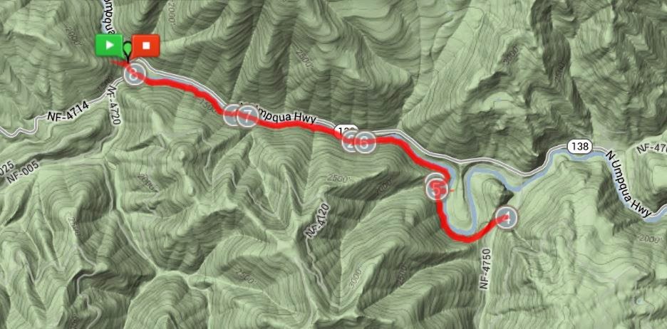
In my ongoing quest to complete the 79-mile N.U.T. (North Umpqua Trail) by the year’s end (which may actually happen earlier than I thought) I decided to take on one section which I haven’t been particularly looking forward to. This would be the 4 mile Calf segment of the N.U.T.
I had 2 reasons for not relishing this part of the trail. For one, this is where the 2002 Apple fire had left it’s unpleasant mark on the trail and hillside. And two, the trail is within sight of the highway for well over half it’s length, giving you that civilized and not-so-secluded feeling. And as everyone knows, seclusion is one of the many reasons we all hike.
 
However, it was part of the trail, and I had to hike it nonetheless, shamelessly using it to achieve my own selfish goal.


I figured since I would have company in the form of vehicle traffic just a stone’s throw away across the river, why not have some human companionship too? So I decided to take my youngest son Colby with me. And I did so without any hesitancy, as I knew his years of ADHD-motivated pacing made him the perfect candidate for keeping up with me on this relatively flat portion of the trail. In fact, I wouldn’t hesitate to drag Colby anywhere I hike, for I know his legs are in better shape than mine. (As I sit writing this within an hour after our hike, he is pacing back and forth in the house, as if the 8 miles he just finished never happened. I hate youth…)
 
We arrived at the trailhead with clear blue skies above us, and the temperature hovering right at freezing. On the bright side, we had no wind chill factor to factor in on this day, so all was well. Literally speaking however, on the not-so bright side, the trail would run along the north side of the hill, offering us a predictable sunless hike, with Mr. Sun shining his teasingly glow on the opposite hillside across the river.
 
 
The first part of the trail was crispy and crunchy under our feet, as we walked upon frozen earth and thin layers of ice crystals. It was a nice contrast to the landscape, being a bit charred from the fire about a dozen years ago. There were plenty signs of life, however, as the undergrowth had already returned, and young trees taller than myself had already begun their upward climb towards the sky.


The trail hugged the river, never straying too far above it, but never getting quite close enough to make a quick jaunt to the water’s edge, just so you can dip your foot into it’s icy chill. Not that I wanted to on this day, but it would’ve been tempting in the summer.


With the river constantly babbling at us and a random vehicle passing by every now and then, we encountered more moss covered rocky hillsides than I had seen in a long time. Seeing all this emerald green lushness, it was hard to imagine incredible heat and destruction had passed through here not so long ago. So far, this hike wasn’t as bleak as I had envisioned it would be, but it still hadn’t impressed me much.
 
 
About a mile or so from Calf Creek, which was our turn around point, the river took a horseshoe bend to the south before turning back toward the north. They call this part of the river Horseshoe Bend. Go figure. It was here, however, that the trail suddenly transformed from an ugly duckling to a swan…


The steep hillside, which had been on one side of us, unexpectedly leveled out, revealing a great view of the terrain through sun-filtered trees. As the trail curved south, we were greeted with those warm, elusive rays, which are highly coveted this time of year. As a bonus, the road, which thus far had been a constant companion, had disappeared far up the opposite hillside out of view, leaving just me, my son, and my other ‘sun’ in the seclusion which, as previously mentioned, is a reason we hike.
 
I think he's happy that the sun arrived


With a renewed pep in our step, we took in views of the horseshoe bend in the river below, pausing to take a few pictures and a quick snack along the way. We circled around to the south, then to the northeast, eventually leaving the sunlit trail, but maintaining a great view of the river below.


We soon reached the end of the Calf segment of the N.U.T. at Calf Creek (go figure), checked the gps at exactly 4 miles, and then turned around.


We hadn’t had a proper sit-down lunch stop yet, so we decided to veer off-trail just a bit (one of my favorite hike-things to do) and found a nice sun-drenched log near the river. After sharing a pepperoni stick and an apple, Colby and I hit the trail again and proceeded further down river.


Saving a tree... wow, he's so strong
As we neared the end of the day’s hike, I thought about this portion of the trail, and what it looks like from the road just on the opposite side of the river. I’ve always observed it from that angle and thought to myself “Well, that doesn’t look like too appealing of a hike, does it?”…


At first glance, the Calf segment is sort of like the ugly step-sister of trails when compared to the rest of the prettier and more popular segments of the trail. It has scars, right there in plain view of all who drive by it.


But, just like in fairytales, once you get past the surface and take a closer look for yourself, the real beauty is revealed in ways you didn’t expect. I believe this happened today...
 

 ...Or, perhaps I just used this part of the trail to help achieve my own selfish goal.